Showing 348 items matching water reserve
-
 Stawell Historical Society Inc
Photograph, John D'Alton water reserve sign on Big Hill
... John D'Alton water reserve sign on Big Hill...John D'Alton water reserve ... grampians Photograph John D'Alton water reserve sign on Big Hill ...John D'Alton water reserve Colour photograph of wooden sign with reservoir in background and wattle on left.stawell -
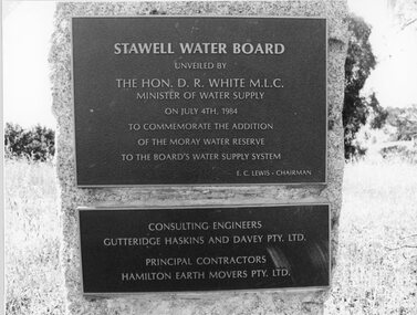 Stawell Historical Society Inc
Photograph, "Moray" Water Reserve Plaque 1984
... "Moray" Water Reserve Plaque 1984...Plaque - Moray Water Reserve 1984... grampians Photograph "Moray" Water Reserve Plaque 1984 Plaque ...Plaque - Moray Water Reserve 1984stawell -
 Rutherglen Historical Society
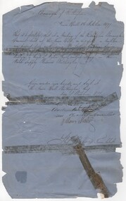
Document - Council permit, 1877 (Exact)
... water supply reserve... shag on the Water Supply Reserve. Mr Gribble was senior... Arthur Gribbin to shoot shag on the Water Supply Reserve... shag on the Water Supply Reserve. Mr Gribble was senior ...Letter granting permission to Mr Arthur Gribbin to shoot shag on the Water Supply Reserve. Mr Gribble was senior Constable of Police stationed at Rutherglen. Water supply came from Lake King in the park. Councillors signing were Geo. Audley / Andrew Hunter (M. Gunter?) William Meehan. [check names - Gribbin - Gribble]Document written in black ink on blue paper, stamped with seal of Rutherglen Municipality, granting permission to Mr Arthur Gribbin to shoot shag on the Water Supply Reserve"Borough of Rutherglen / Town Hall / Rutherglen / 1st October 1877" Signed by Councillors and Town Clerk Thos. Reevespermit, water supply reserve, lake king, shag, rutherglen borough -
 Trentham and District Historical Society
photograph, ? Caspar
... and the Water reserve...., the Caspar family lived on McMenamin's Lane and the Water reserve ...? Caspar, the Caspar family lived on McMenamin's Lane and the Water reserve.people -
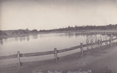
 The Beechworth Burke Museum
Photograph - Postcard, c1900
... water reserve... significant as it provides insight into the water reserves of Victoria ...The construction on Lake Kerferd began in 1862 however it wasn't completed until 1874 due to engineering and funding issues. The lake was named after George Briscoe Kerferd (1831–1889) who was responsible for Beechworth's water scheme. George Briscoe Kerferd was born on 21 January 1831 in Liverpool, England and arrived in Melbourne April 1853. He spent his first years in Australia in Bendigo before settling down in Beechworth as a wine and spirits merchant. He married Ann Martindale on 17th December 1853 at St James Cathedral, Melbourne and between them they had three sons and five daughters. Kerferd began his political and legal career in Beechworth when he was first elected to the Municipal Council in May 1857. Later he would be elected to the Legislative Assembly for the Ovens District in November 1864, and continued to represent the area until February 1886. This photograph is historically significant as it provides insight into the water reserves of Victoria. It also demonstrates the political identity of George Briscoe Kerferd and the Beechworth Municipal Council.Sepia rectangular postcard printed on paperObverse: Reverse: 83-131-1/ Post Card/ Correspondence / Address Only / BMM2997 / 53 / [Kodak Australia Stamp] lake kerferd, beechworth, water scheme, water reserve, reservoir, legislative assembly, hon. george briscoe kerferd, catchments, beechworth water reserve, beechworth catchments, municipal council, st. james cathedral, lakes, reserve, water supply, political projects -
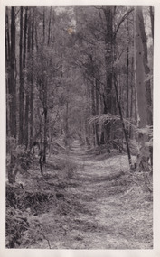 The Beechworth Burke Museum
Photograph, Christmas 1941
... water reserve... of the water reserves of Victoria. It is also linked to political ...Taken on Christmas of 1941, shown is a track to Lake Kerferd with forest on both sides. The construction on Lake Kerferd began in 1862 however it wasn't completed until 1874 due to engineering and funding issues. The lake was named after George Briscoe Kerferd (1831–1889) who was responsible for Beechworth's water scheme. George Briscoe Kerferd was born on 21 January 1831 in Liverpool, England and arrived in Melbourne April 1853. He spent his first years in Australia in Bendigo before settling down in Beechworth as a wine and spirits merchant. He married Ann Martindale on 17th December 1853 at St James Cathedral, Melbourne and between them they had three sons and five daughters. Kerferd began his political and legal career in Beechworth when he was first elected to the Municipal Council in May 1857. Later he would be elected to the Legislative Assembly for the Ovens District in November 1864, and continued to represent the area until February 1886.This photograph is historically significant as it provides insight into surrounding areas of the water reserves of Victoria. It is also linked to political identity of George Briscoe Kerferd and the Beechworth Municipal Council.Black and white rectangular photograph printed on matte photographic paper.Obverse: Reverse: 8163/ Back track to Lake Kerford/ Beechworth/ Xmas 1941lake kerferd, beechworth, water scheme, water reserve, forest track, forest pathway, reservoir, legislative assembly, hon. george briscoe kerferd, catchments, beechworth water reserve, beechworth catchments, municipal council, st. james cathedral, lakes, reserve, water supply, political projects -
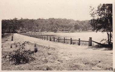
 The Beechworth Burke Museum
Photograph - Post Card, 1920-1930's
... water reserve... scheme water reserve reservoir Legislative Assembly Hon. George ...Taken between 1920-1930s, shown is the banks of Lake Kerferd with wooden man-made fencing. The construction on Lake Kerferd began in 1862 however it wasn't completed until 1874 due to engineering and funding issues. The lake was named after George Briscoe Kerferd (1831–1889) who was responsible for Beechworth's water scheme. George Briscoe Kerferd was born on 21 January 1831 in Liverpool, England and arrived in Melbourne April 1853. He spent his first years in Australia in Bendigo before settling down in Beechworth as a wine and spirits merchant. He married Ann Martindale on 17th December 1853 at St James Cathedral, Melbourne and between them they had three sons and five daughters. Kerferd began his political and legal career in Beechworth when he was first elected to the Municipal Council in May 1857. Later he would be elected to the Legislative Assembly for the Ovens District in November 1864, and continued to represent the area until February 1886.The postcard holds Historic significance due to its connection to Beechworth and its Lake Kerford. It demonstrates the interactions between nature and colonialists, especially how the lake has somewhat been 'protected' with the man made fencing. It also presents information on the environmental development or degradation for the area, with possible changes to the environment that may have been caused by human physical forces, natural decay or Global Warming.Black and white rectangular postcard printed on paper.Obverse: Lake Kerferd, Beechworth / Reverse: 8164 / Post Card / Correspondence / Address Only / Kodak Austral [Kodak Australia Stamp] /lake kerferd, beechworth, water scheme, water reserve, reservoir, legislative assembly, hon. george briscoe kerferd, catchments, beechworth water reserve, beechworth catchments, municipal council, st. james cathedral, lakes, reserve, water supply, political projects, man-made fence, environmental changes -
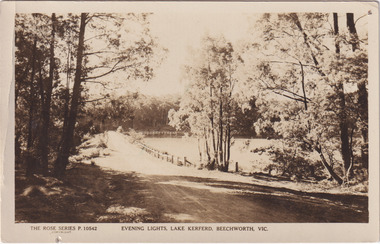 The Beechworth Burke Museum
Photograph - Post Card, Rose Series Stereograph Co. Postcard
... water reserve... scheme water reserve reservoir Legislative Assembly Hon. George ...The construction on Lake Kerferd began in 1862 however it wasn't completed until 1874 due to engineering and funding issues. The lake was named after George Briscoe Kerferd (1831–1889) who was responsible for Beechworth's water scheme. George Briscoe Kerferd was born on 21 January 1831 in Liverpool, England and arrived in Melbourne April 1853. He spent his first years in Australia in Bendigo before settling down in Beechworth as a wine and spirits merchant. He married Ann Martindale on 17th December 1853 at St James Cathedral, Melbourne and between them they had three sons and five daughters. Kerferd began his political and legal career in Beechworth when he was first elected to the Municipal Council in May 1857. Later he would be elected to the Legislative Assembly for the Ovens District in November 1864, and continued to represent the area until February 1886. The postcard holds Historic significance due to its connection to Beechworth and its Lake Kerford. It demonstrates the interactions between nature and colonialists, especially how the lake has somewhat been 'protected' with the man made fencing. It also presents information on the environmental development or degradation for the area, with possible changes to the environment that may have been caused by human physical forces, natural decay or Global Warming.Sepia rectangular postcard printed on paper.Obverse: The Rose Series P. 10542 / Copyright / Evening lights, Lake Kerferd, Beechworth, VIC Reverse: Farley / Published by the Rose Stereograph Co., / Armadale Victoria. / 84-132-1 / Post card / The "Rose" Series De Luxe / A Real Photograph Produced in Australia / BMM299 lake kerferd, beechworth, water scheme, water reserve, reservoir, legislative assembly, hon. george briscoe kerferd, catchments, beechworth water reserve, beechworth catchments, municipal council, st. james cathedral, lakes, reserve, water supply, political projects, rose series, postcard, rose series stereograph -
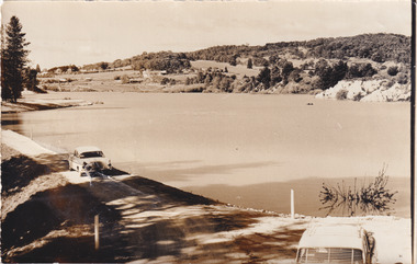 The Beechworth Burke Museum
Photograph, 1960s
... water reserve... of Beechworth district. Beechworth water scheme water reserve catchments ...Taken around 1960s, this photograph shows the banks of Lake Sambell. Lake Sambell is named after Mr. L. H. Sambell who was instrumental in the lake's formation. Lake Sambell is the original site of the open sluice operation of Rocky Mountain Mining Company in the 1800s and the early 1900s. In the early 1920s, it was reconstructed as a recreational lake and was formally opened to public on 6 October 1928. The opening event was attended by townspeople and Beechworth's Minister of Lands Mr. Bailey. In the late 1930s to early 1940s, Lake Sambell redeveloped. The first development aimed to raise the banks by six feet to double its present area and to make the water cleaner. Another redevelopment in the 1940s was made possible by the Beechworth and District Progress Association. It involved raising the banks to five feet to provide swimming facilities, paddling pool and caravan park. This photograph holds Historic significance because of its connection to the development of Beechworth district.Sepia rectangular photograph printed on matte photographic paperObverse: Reverse: 3533 /beechworth, water scheme, water reserve, catchments, beechworth water reserve, beechworth catchments, municipal council, lakes, reserve, water supply, political projects, environmental changes, mr. l. h. sambell, sambell, rocky mountain mining company, recreational lake, minister of lands, mr. bailey, swimming pool, paddling pool, caravan park, swimming facilities, lake redevelopment, funding -
Stawell Historical Society Inc
Map, T.F. McGauran, William Couty of Borong 1891, 1891
... Stawell Water Supply Reserve. Grampians State Forest. Dairy...A2 Parish Map of Willam Inculdin Stawell Water Supply... Inculdin Stawell Water Supply Reserve and Creeks. Marked in red ...Stawell Water Supply Reserve. Grampians State Forest. Dairy Creek, Fyans Creek, Barney's Creek, Bovine Creek, Glasstree Creek, Stoney Creek. Stawell Water Supply Aquaduct Fkuming Tunnel.A2 Parish Map of Willam Inculdin Stawell Water Supply Reserve and Creeks. Marked in redPhoto Lithographed at the Department of Lands and Survey Melbourne. By T.F. McGauran 20.07.91 water supply survey -
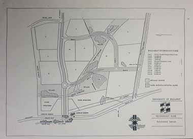 Federation University Historical Collection
Plan - map, Ballarat Technology Park Wetlands Reserve and water retention basins, c1999
... Ballarat Technology Park Wetlands Reserve and water... Plan Ballarat Technology Park Wetlands Reserve and water ...Yellow A4 page with a subdivision layout of the Ballarat Technology Park. It shows the Canadian Wetlands Researve and the water retentino.Detention Basins.canadian wetlands, ballarat technology park, mount helen campus -
 Federation University Historical Collection
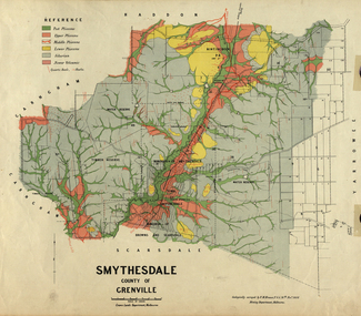
Plan, Smythesdale, County of Grenville, 01/12/1892
... , Browns and Scarsdale, allotments, water reserve, Timber reserve... of Smythesdale, Smythesdale, Browns and Scarsdale, allotments, water ...This plan is associated with former Ballarat School of Mines Student Richard Squire (1875-1876). Gift of the Squire FamilyA plan showing the Borough of Smythesdale, Smythesdale, Browns and Scarsdale, allotments, water reserve, Timber reserve, Nintingbool Pre-emptive Right, Reserve for public gardens, Reserve for Cricket Ground, Reserve for Reservoirsmythesdale, scarsdale, browns, yarrowee, carngham, samuel barlett, sheridan, wrigley, p. land, r. simpson, d. davis, nintingbool, mclachlan, a. mclachlan, c. taylor, w. c. smith, d. davies, w. williams, m. jones, t. mcgurk, r. selkirk, a. mooney -
Hand Tool Preservation Association of Australia Inc
Diagram
... Diagram reserve water supply... No physical address melbourne Diagram Diagram reserve water supply ...This item is part of the Thomas Caine Tool Collection, owned by The National Trust of Australia (Victoria) and curated by the Hand Tools Preservation Association of Australia.Diagram reserve water supply -
 Federation University Historical Collection
Plan, Haddon, County of Grenville, 1932, 13/04/1932
... water supply reserve....: 16.1km haddon grenville cardigan water supply reserve nentingbook ...The Haddon Parish Plan shows crown parcels government roads, Crown Reserves, Railway. Scale 40 chains to 1" (1:31, 680) WGS 84 Centroid Lat: 37 degrees 34' 00" S Long: 148 degrees 40' 20" E N.S. 9.3km E.W.: 16.1kmhaddon, grenville, cardigan, water supply reserve, nentingbook pre-emptive right, a. mclachlan, lake burrumbeet, e.a. wynne, p. russell, b. hepburn, benjamin hepburn, nentingbool, t.c. wilson, j. amoy, william collard smith, james roach, j. mitchell -
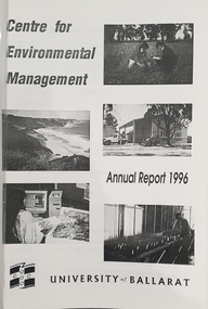 Federation University Historical Collection
Booklet, University of Ballarat Centre for Environmental Management, 1996
... and water assessment conservation reserve management paul ryan ...The Centre for Environmental Management as established in July 1995 as a strategic development initiative to consolidate the University's position as a centre for industry linked environmenttal teaching, resarech and consultancy. Page 19 "SPECIAL INITIATIVES Establishment of field Research Stations Two areas of concentration of research effort for the Centre are the Otways in the south western Victoria and the Scotia Country in the rangelands of NSW. In both these areas it is essential that ther be a secure accomodation abase for research students. In the former case there is a need for a sheltered base to enable year round field work in cold wet conditions and in the latter a base with a reliable water supply and the facilities to allow field work in very hot dry conditions which prevail from much of the year. It has been an ibjective of the Centre to establish field stations at these two sites and considerable progress has been made through the year. (i) Nanya Field Station in the Scotial Country Through the generosity of the owner, Mr Rob Taylor, an unused homestead on Nanya Station was made available to the Centre. Largely through voluntary labour during research field trips during the year this previously derelict homestead has been restored to functionality and now has facilities for up to 20 research workers with a reliable water supply, cooking, washing, and refrigeration facilities. (ii) Cape Otway Resaerch Centre Negotiations have continued through the year with the potential lessees of the Cape Otway Lighthouse Precinct with the support of the Vice Chancellor and other potential user groups within the University these have reached a successful outcome. The University will be working with the lessees to develop the historic Telegraph Station as a dual purpose facility for interpretation and research." Black and white cover with clear plastic sheet. university of ballarat, centre for environmental management, martin westbrooke, richard mcewan, mal weston, john miller, nanya, telegraph station, cape otway, cape otway lighthouse station, cape otway telegraph station, field resaerch stations, s. hadden, peter dahlhaus, r.j. macewan, pat prevett, native vegetation assessment, fauna management, pest plants and animal research, soil and water assessment, conservation reserve management, paul ryan, richard macewan -
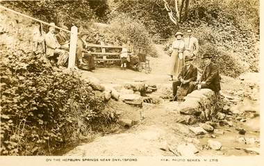 Ballarat Heritage Services
Postcard, On the Hepburn Springs near Daylesford
... . hepburn springs mineral water hepburn springs reserve ...Black and white postcard of Hard Hill Spring, Daylesford.hepburn springs, mineral water, hepburn springs reserve -
 Ballarat Heritage Services
Photograph - Photograph - Colour, Locarno Spring in the Hepburn Springs Reserve, 2019, 22/04/2019
... locarno mineral water Hepburn Springs Reserve Clare Gervasoni ...Colour photograph of the Locarno Spring at Hepburn Mineral Springs Reserve.hepburn springs, locarno, mineral water, hepburn springs reserve -
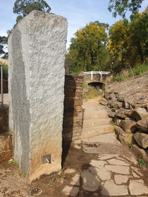
 Ballarat Heritage Services
Photograph - Photograph - Colour, The Edna Walling Bridge at Locarno Spring in the Hepburn Springs Reserve, 2020, 12/12/2020
... at Locarno Spring in the Hepburn Springs Reserve, 2020 Colour ...The Hepburn Springs Progress Association invited Edna Walling the the Hepburn Springs Reserve, and sandstone paths and bridges resulted. In 1934 there was a proposal to spend 2,000 to 3,000 poinds at the Hepburn Springs Reserve, with a govenrment loan suggested. Colour photograph of the stone bridge at Locarno Spring in the Hepburn Springs Reserve.hepburn springs, locarno, mineral water, hepburn springs reserve, locarno spring, edna walling -
 Ballarat Heritage Services
Photograph - Photograph - Colour, Looking Towards Locarno Spring and the Pavilion at Hepburn Springs Reserve, 2020, 22/04/2019
... mineral water Hepburn Springs Reserve Hepburn Springs Pavilion ...Colour photograph of a view of the Hepburn Mineral Springs Reserve looking towards Locarno Spring and the Pavilion.hepburn springs, locarno, mineral water, hepburn springs reserve, hepburn springs pavilion, locarmo spring -
 Ballarat Heritage Services
Photograph - Photograph - Colour, The Edna Walling inspired stonework at Locarno Spring in the Hepburn Springs Reserve, 2020, 12/12/2020
... stonework at Locarno Spring in the Hepburn Springs Reserve, 2020 ...The Hepburn Springs Progress Association invited Edna Walling the the Hepburn Springs Reserve, and sandstone paths and bridges resulted. In 1934 there was a proposal to spend 2,000 to 3,000 pounds at the Hepburn Springs Reserve, with a govenrment loan suggested. Colour photograph of the stone bridge at Locarno Spring in the Hepburn Springs Reserve, with the new 'placed' rocks in the surrounds c2000hepburn springs, mineral water, hepburn springs reserve, edna walling -
 Ballarat Heritage Services
Photograph - Photograph - Colour, The Edna Walling Bridge at Locarno Spring in the Hepburn Springs Reserve, 2020, 12/12/2020
... at Locarno Spring in the Hepburn Springs Reserve, 2020 Colour ...The Hepburn Springs Progress Association invited Edna Walling the the Hepburn Springs Reserve, and sandstone paths and bridges resulted. In 1934 there was a proposal to spend 2,000 to 3,000 poinds at the Hepburn Springs Reserve, with a govenrment loan suggested. Colour photograph of the stone bridge at Locarno Spring in the Hepburn Springs Reserve, with the new 'placed' rocks in the surrounds c2000hepburn springs, locarno, mineral water, hepburn springs reserve, locarno spring, edna walling -
 Ballarat Heritage Services
Photograph - Photograph - Colour, Looking Towards Locarno Spring and the Pavilion at Hepburn Springs Reserve, 2020, 22/04/2019
... mineral water Hepburn Springs Reserve Hepburn Springs Pavilion ...Colour photograph of a view of the Hepburn Mineral Springs Reserve looking towards Locarno Spring and the Pavilion.hepburn springs, locarno, mineral water, hepburn springs reserve, hepburn springs pavilion, locarmo spring -
 Tarnagulla History Archive
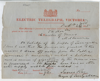
Telegram: Mayor of Tarnagulla to the Minister of Mines, Melbourne, 22nd February 1865
... that the permission granted to two miners to draw off water from the Public ...Murray Comrie Collection. A telegram sent from James Ray, Mayor of Tarnagulla to the Minister for Mines, Melbourne on 22nd February 1865. Reads: "On behalf of the people of Tarnagulla I have to ask that the permission granted to two miners to draw off water from the Public Reservoir be suspended until a petition now in course of signatures by the miners can be forwarded. The public here have no other water supply within five miles."tarnagulla, post office, telegrams, minister mining, mining, water, reservoir, recreation reserve, resources -
 Federation University Historical Collection
Map, Smythesdale, County of Grenville, 1888, 1889
... information on the water reserve, worked quartz veins, Watson's Hill... by F.M. Krause and includes information on the water reserve ...The map maker, Ferdinand M. Krause, was a professor at the Ballarat School of Mines. This land was printed form the Crown Lands Department, Melbourne. Coloured map of the County of Grenville. The edge has been taped. The scale is 40 chains to 1 inch. The map is accompanied with a foolscap sheet printed by the Mines Department in 1898. It is a Report on the Parish of Smythesdale by F.M. Krause and includes information on the water reserve, worked quartz veins, Watson's Hill, Surface Hill and Sugarloaf Hill, Haddon, Trunk Lead and the Crucible Shaft. smythesdale, krause, f.m. krause, ferdinand krause, nitingbool, watson's hill, surface hill, sugarloaf hill, haddon -
Port Melbourne Historical & Preservation Society
Document - Receipt, Melbourne Water Supply, 1880s
... gallons of water to ornamental reserve, Nott Street, Port... gallons of water to ornamental reserve, Nott Street, Port ...Receipt from Melbourne Water Supply for supply of 47,000 gallons of water to ornamental reserve, Nott Street, Port Melbourne 1880ssport - lawn bowls, parks and gardens, port melbourne bowling club, henry norval edwards, michael tarver quinn, local government - borough of sandridge -
 Ballarat Heritage Services
Photograph - Colour, Locarno Spring at Hepburn Springs
... the waters' at Locarno Mineral Water Spring, Hepburn Springs Reserve. ... the waters' at Locarno Mineral Water Spring, Hepburn Springs Reserve ...Black and white image of a number of people 'taking the waters' at Locarno Mineral Water Spring, Hepburn Springs Reserve. hepburn springs, locarno spring, hepburn springs reserve -
 Phillip Island Conservation Society Inc.
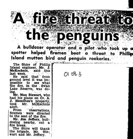
Work on paper - Photocopy of newspaper cutting, Wonthaggi Express or Powlett Express newspaper, "A fire threat to/the penguins", 28.01.1965
... in January 1965 at Swan Lake, a water reserve at the entrance..., a water reserve at the entrance to Summerland Peninsula, Phillip ...The article describes a fire incident which took place in January 1965 at Swan Lake, a water reserve at the entrance to Summerland Peninsula, Phillip Island. Due to an extremely heavy infestation of gorse (noxious weed) and natural tea tree scrub, along with poor vehicle access, the volunteer fire fighters could apparently not gauge the extent of the fire. A light plane operator visiting Cr Arthur Hamilton nearby was able to fly Phillip Island Shire Engineer, Jock McKechnie, over the lake to better direct the fire fighters. Swan Lake has many Bunurong Aboriginal middens and short-tailed shearwater rookeries, and, being not far from the Penguin Parade, a fire there posed a direct threat to the birds. The article is significant because it indicates the vulnerability of the Summerland Peninsula reserves to fire, the way the Shire Engineer, local bulldozer contractor and volunteer fire fighters tackled the fire outbreak. photocopy of newspaper cutting. Dark copying at top. Double column heading. Single column black text on white paper28-1-65 EXswan lake phillip island, summerland peninsula, bunurong aboriginal middens, short-tailed shearwaters, mutton birds, little pengiuns, penguin parade, jock mckechnie, cr arthur hamilton, fire fighters, , max stewart, jim jeffery -
 Federation University Historical Collection
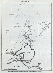
Image, Batman's Map of Port Phillip
... reserve, fresh water... plains, public common reserve, fresh water "A tract of country ...Scanned from "The Old Pioneers' Memorial History of Melbourne From the Discovery of Port Phillip to the World War". It is a facsimile map from the House of Commons Reports of Committee.John Batman's map of Port Phillip showing Dutigalla (Batman's Tract), a township reserve, open plains, public common reserve, fresh water"A tract of country [called?] by the native chief of Southern Ausralia to be John Batman 6th June 1935."port phillip bay, john batman, melbourne, iramoo, r. sarsh, river sarsh, river batman, yarra river -
 Federation University Historical Collection
Map, Ballaarat Gold Field, 1861, 21/10/1861
... , waterways, mines, churches, schools, water races, and garden... showing property, waterways, mines, churches, schools, water races ...A party of surveyors camped by Yuille's Swamp (later Lake Wendouree) and surveyed the countryside for a map to be produced by the Geological Survey of Victoria. In November 2004 the Central Highlands Regional Library presented a special edition of 200 copies of the 1861 map reproduced from a copy in their collection. Original geological map of Ballarat showing property, waterways, mines, churches, schools, water races, and garden reserves. It was compiled and drawn from the surveys of Mining Surveyors Davidson, Fitzpatrick and Cowan.Compiled & Drawn from the Survey of Mining Surveyors Davidson, Fitzpatrick and Cowan & the Plans in the Surveyor General's Office by J. Brahe, 21st October 1861. R. Brough Smyth, Secretary for Mines. The Honourable J.B. Humffray, M.L.A. Commr of Mines.ballarat, map, davidson, robert brough-smyth, fitzpatrick, cowan, yuille's swamp, public garden reserve, manure depot, black hill, ballarat east, old post office hill, pennyweight hill, claytons hill, golden point, mining, railway, cricket ground, swamp creek, cemetery, sludge reserve, bakery hill, gaelic church, juvenile reformatory, orphanage, specimen hill, eureka lead, cattle yard hill, dalton's flat, chinese village, poverty hill, railway reserve, little bendigo diggings, pound reserve, allied armies, flour mill, agricultural reserve, marsh, survey reserve, survey corps, white flat, yarrowee, yarrowee creek, brache, j. brache, survey, ballaarat gold field 1861 -
 City of Moorabbin Historical Society (Operating the Box Cottage Museum)
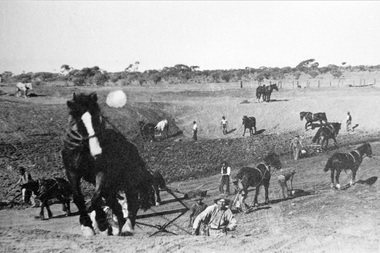
Photograph, Black & White Horse drawn scoops earthwork in Moorabbin Shire c1900, c1900
... , establishing sizeable dams for important water reserves for community... and early 1900's, establishing sizeable dams for important water ...The, horse drawn metal scoop ,guided by a man, was used to clear earth for road making. Well before the introduction of motorised, mechanical graders and trucks the painstaking, labour-intensive work was undertaken by large teams of sturdy men using strong horses such as the draught horse. Roads were needed by the market gardeners to transport their produce to market. Later as the heavy wagon loads continually caused ruts and general degradation of the roadways a Plateway system was installed so that the wagon wheels could roll along the rails thus protecting the roadways. August 31st 2021 Ron Nash, from WA, informs us "The men and horses pulling earth scoops in the photo are not moving earth for road making - they are excavating an "earth tank", or dam, as described in common nomenclature today. This skill was known as "tank sinking", and tank sinkers were active in many rural and remote areas in the 1800's and early 1900's, establishing sizeable dams for important water reserves for community and farm and railway use. With the advent of mechanised equipment such as bulldozers, the trade of tank sinking was still carried out, but on a faster basis. I am a former tank sinker and earth moving contractor, now long retired." Early settlers in Moorabbin Shire had to build the roads, plateways, drains, as the settlement of the land, in Dendy's Special Survey 1841 Brighton, spread and market gardeners need to transport their produce to market. Their most valuable possession was the draught horse that was used for ploughing, drawing carts and these scoops.Black & White photograph showing many horses pulling metal scoops guided by men to move earth for road making in Moorabbin Shire c 1900Back Handwritten Informationplateway, roadworks moorabbin shire, draught horses, metal scoops, paviers, box alonzo, smith j l; chaff cutter, horse drawn carts, toll gates brighton, motor cars 1900, steam engines, early settlers, bentleigh, mckinnon, parish of moorabbin, city of moorabbin, county of bourke, moorabbin roads board, shire of moorabbin, henry dendy's special survey 1841, were j.b.; bent thomas, o'shannassy john, king richard, charman stephen, highett william, ormond francis, maynard dennis, market gardeners, vineyards, orchards